Travels
First stop, Interlaken.
Petra
and I stopped in Interlaken on our slow route to Lake Garda in August
'99. We decided to ride up to the Kleiner Scheidegg above Wengen. The
route starts in Interlaken heading up the valley past Gündlischwand
to Grindelwald, and then climbing steeply up to the Kleiner Scheidegg
(and optionally the Eigergletscher Station). From here, you ride the
Wengen world cup downhill run down via Wengen, then Lauterbrunnen and
back to Interlaken. 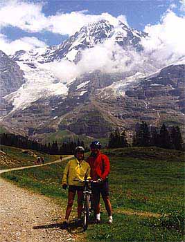
Setting off on the flat valley floor, we followed the red cycling path signs to Wilderswil, Gsteigwiler, and Gündlischwand, then all the way up the valley to Grindelwald. It's an easy hour or so ride along the bike trail and acts as a good warm up for the next section. In the village of Grindelwald, we had our first coffee break whilst the weather cleared, treating us to fantastic vistas of the North face of the Eiger.
Just before Grindelwald itself, we followed the red bike signs to the Kleiner Scheidegg and more specifically Brandegg. For the first four kilometres it's a sealed road but this eventually turns into a forestry road and then for the next two hours it's a solid climb up to Kleiner Scheidegg (2061m above sea level). It's a good tough climb to the top, and in the heat we took several breaks. Each time we looked around we had an even better view of some of the best scenery in Switzerland, especially with the Eiger north-face looming above us in the clowds and the view across the valley to the Großer Scheidegg. This climbing section is one that can be a bit busy with hikers but the road is wide enough to make it easy enough to get around them. The last two kilometers are steep but rideable, so if you're fit you shouldn't need to get off and push the bike.
At
the Jungfraujoch (the highest train station in the world), we stopped
for hearty lunch at the Eigernordwand restaurant, followed by a recovery
rest (witnessed in Petra's relaxed pose!). You could keep on cycling up
to the Eigergletscher Station (2320m above sea level). Most of this can
be ridden but there is a section where
you have to get off and carry your bikes. The
station is as far as you can possibly go on the bike, and is crowded
with tourists who have paid over Sfr100 to get there by train. 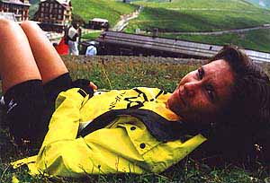 The Jungfraujoch
(literally 'Virgin's Pass'!) is a tourists playground, with over inflated
prices, menus in English and Japanese, and thousands of cameras on
display, so we didn't stay any longer than neccessary.
The Jungfraujoch
(literally 'Virgin's Pass'!) is a tourists playground, with over inflated
prices, menus in English and Japanese, and thousands of cameras on
display, so we didn't stay any longer than neccessary.
The total trip distance was 60kms with 1400m of climbing which took Petra and I about 4½ riding hours (6 hours total).
Second Stop, Lugano.
Petra and
I rode up to Monte Tamaro in Lugano, first setting out
along
the
Via San Gottardo in the Veddegio river valley, heading North. This
is marked by a cycle track, signalled with red
arrow-shaped signs, running up the river valley and mainly on fire
roads. 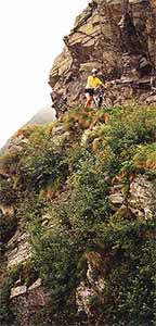 After about 15 kilometers, at the ski-lift for Monte Tamaro, you
have the
choice of either climbing
the fire trails to the top of the ski lift, or take the lift itself
which gains 1000m vertical and costs about Sfr18 ($10). Needless to say,
we opted
for the easy approach.
After about 15 kilometers, at the ski-lift for Monte Tamaro, you
have the
choice of either climbing
the fire trails to the top of the ski lift, or take the lift itself
which gains 1000m vertical and costs about Sfr18 ($10). Needless to say,
we opted
for the easy approach.
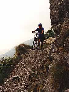
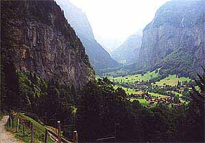
At the top lift station (1500m), we climbed the gravel fire road opposite the station towards the radio antenna. This was a very steep (just rideable) fire road which is about 3 kilometers long, climbing steeply into the gathering fog. After about 40 minutes, we reached the radio antenna and kept going along the marked hiking/biking trail (still marked with red cycle signs now and then). We walked most of the next 2 kilometers, as the track is very narrow, rough and any wipeout would have been fatal! We passed two mountain refuges, and traversed across and around the summit. This meant walking along a path cut into the sheer cliff face until we reached a split in the path (see below). This was the start of the downhill (following the yellow walking sign to Arosio), but because the path was a dangerous switchback, we both walked the first few turns. After that, it levelled out into a rocky, bumpy ride running along the hillside, dropping about 1000m vertival over the 20 kilometers back towards Lugano. Most of this was on single track through rocky terrain and/or woods with wickedly knarly tree roots. Toward the bottom, we tried an alternative route marked as 'challenging': this turned out to be a wild and almost unrideable trail suitable only for the crazy kids and certainly beyond both of us. Eventually we joined a fire trail, and coasted along this, following the bike signs to Bosco Lagasnese. At this town, we opted to ride the road down, returning to Lugano after 50kms of riding or about 4 hours of riding.
The downhill portion is an amazing ride: technical but not too difficult. It starts in wild open mountainside with amazing views, then runs forever at a gentle but fun gradiant through the forest. Lower that seat, soften your suspension, and have fun!
I found both these routes by scouring articles written by other bikers in the mtbr website. Check it out here.